
Unlocking the River Frontier for Multi-Day Paddlers
A multi-day river expedition offers a rare combination of movement and stillness. The current carries you through changing landscapes by day, while a quiet gravel bar or sandy bank can become a temporary camp by evening. Falling asleep to moving water, waking beneath a pale river fog, and launching directly from camp are among the great rewards of canoeing, kayaking, and packrafting far from roads.
Yet a river corridor is not automatically a public campground. The water may be open to navigation while the banks, streambed, or islands remain privately owned. That distinction creates the central planning challenge: how to find a legal place to stop without crossing private land or placing a tent in a dangerous flood zone. Understanding navigability, the Ordinary High Water Mark, local access rules, and changing water conditions helps prevent trespass claims, fines, damaged gear, and unsafe bivouacs. It also makes the journey more relaxed because every landing has been considered before the current carries you there.
The Public Trust Doctrine and Navigability on Moving Water
The legal starting point is navigability. In many jurisdictions, a river is considered navigable when it has historically been used, or could have been used in its ordinary condition, as a commercial highway. Modern recreational use is not always required. Other states apply a more practical test, such as whether a canoe or small watercraft can float during some recurring period of the year. Wisconsin, for example, recognizes navigable waterways through recurring floating conditions rather than requiring water to be present continuously.
Where the doctrine applies, the public may have protected rights to travel, float, fish, and enjoy the waterway. Wisconsin describes its Public Trust Doctrine as protecting navigation and transportation, recreation, scenic enjoyment, water quality, and aquatic habitat. The principle has deep historical roots, but it does not create unlimited freedom along every inch of the riverbank. A useful explanation of the principle is that The Public Trust Doctrine guarantees civic passage along waterways, while individual states define the precise scope of access and enforcement.
For paddlers, the crucial distinction is between public use of the water and access across land. A state may hold the bed of a navigable river in trust, yet an adjacent landowner may still own the bank above the legally recognized water mark. Pennsylvania guidance, for example, explains that the public may boat, float, wade, fish, swim, and recreate in public waters after entering lawfully, but may not cross private property to reach them. In practice, plan every launch and takeout through a public ramp, road right-of-way, bridge access, permission-based property, or another clearly lawful route.
- Confirm whether the river is legally navigable in the state where the trip occurs.
- Identify legal launch points before beginning the expedition.
- Keep navigation, fishing, and shoreline camping legally separate in your planning.
- Treat posted private land, buildings, lawns, cultivated fields, and fenced areas as off limits.
- Check whether local rules add restrictions to state-level access rights.
Reading the Ordinary High Water Mark on the Bank
The Ordinary High Water Mark, commonly abbreviated OHWM, is the physical boundary that often separates the river”s legally influenced area from upland private property. It is not simply the highest point reached by an exceptional flood, nor is it always the visible edge of water on the day you arrive. Wisconsin defines it through evidence created by the continuous and recurring action of water, including erosion, soil changes, staining, debris patterns, and the destruction or absence of terrestrial vegetation.
Look for several indicators together rather than relying on one feature. A distinct band of darker or compacted soil, a line of deposited leaves and driftwood, exposed roots, a break from flood-tolerant plants to upland vegetation, or a small terrace shaped by repeated flows can help reveal the boundary. On broad rivers, the OHWM may run behind the present waterline during a low-water season. On narrow, steep channels, it may be difficult to distinguish from ordinary bank erosion. A single wet patch or isolated high-water stain is not enough to establish the line confidently.
State law can change the practical result. Montana”s Stream Access Law generally permits recreational use up to the OHWM, but it does not authorize crossing posted private land or walking across private property to reach the stream. Public access may be available at a bridge or county road right-of-way, and special rules may apply in national parks, reservations, refuges, or other managed areas. In stricter eastern jurisdictions, the public may be able to float through a navigable corridor while having little or no right to camp on exposed streambed or gravel. When a campsite sits near the boundary, assume uncertainty favors asking permission or moving on.
- Start at the active channel and trace the repeated flood and erosion evidence upward.
- Compare vegetation changes on both sides of the river, especially where flood-tolerant plants give way to stable upland growth.
- Inspect soil color, staining, deposited debris, exposed roots, and natural terraces as a group.
- Do not treat a sandbar as automatically public simply because it is surrounded by water at one moment.
- Use state agency maps and prior OHWM determinations where available, then confirm conditions in the field.
State by State Water Access Rules at a Glance
River access law is highly regional, so a general principle should never replace local research. Pennsylvania generally recognizes public rights on navigable waters after lawful entry, while non-navigable streams are often private, although navigation or floating rights may still exist. Wisconsin uses recurring canoe or small-craft floatability as part of its navigability analysis and relies on the OHWM to divide waterway regulation from shoreland controls. Montana provides a comparatively strong recreational stream-access framework up to the OHWM, but prohibits crossing private land without an authorized route.
Camping is a separate question from passage. A low gravel bar may be usable in one state, restricted in another, and privately owned in a third. Even where temporary landing is tolerated, overnight occupation, fires, fishing from the bank, or walking above the OHWM may require permission. Portaging also deserves careful attention. A right to navigate around an obstruction does not always mean a right to cross a private yard, dock, or field. Scout dams, strainers, fences, and hazardous rapids from the water when possible, and use designated portage routes or obtain landowner permission before carrying around an obstacle.
| Jurisdiction or model | Water access principle | Camping and bank considerations |
|---|---|---|
| Pennsylvania | Navigability is strongly connected to historic or potential commercial use; public rights apply after lawful entry. | Public water use does not grant permission to cross private land or occupy privately owned banks. |
| Wisconsin | A waterway may be navigable when a canoe or small craft can float during recurring conditions. | The OHWM guides regulatory boundaries, but local zoning and ownership questions still apply above it. |
| Montana | Recreational use is generally allowed up to the OHWM on streams covered by the Stream Access Law. | Do not cross posted private property; use public bridges, roads, and authorized access points. |
| Other states | Rules vary widely according to navigability tests, streambed ownership, easements, and public trust provisions. | Verify sandbar, dry-bed, overnight camping, and portage rights with the relevant agency. |
Scouting Flood-Safe and Responsible Bivouac Sites
Legal access is only half the campsite decision. River levels can rise while the sky above camp remains clear. Before launching, inspect upstream weather forecasts, rainfall totals, snowmelt conditions, reservoir operations, and dam-release schedules. A hydrograph is more useful than a single gauge reading because it shows whether the river is steady, rising, or beginning a delayed surge. Contact the dam operator or managing agency when release information is available, and build a conservative margin into the route plan.
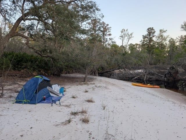
On arrival, reject low islands, inside bends with fresh debris, flat beaches below obvious flood lines, and any site with a channel or backwater route between the tent and higher ground. Look for driftwood lodged in branches, mud lines on trunks, fresh sediment, and scoured vegetation. Camp above the highest visible flood evidence when feasible, while remaining below the legal boundary and away from unstable cutbanks. Secure boats, paddles, and dry bags with reliable anchor lines placed high enough to accommodate a rise, but avoid tying directly to fragile vegetation. Never rely on a single line or assume a calm evening guarantees a calm night.
River ecosystems are especially vulnerable because repeated camps can concentrate fire scars, food scraps, toilet waste, and vegetation damage in a narrow corridor. Apply strict Leave No Trace practices: use durable surfaces, keep groups compact, avoid trampling green banks, and carry out all trash and food residue. Where local regulations or conditions make human-waste disposal difficult, pack-out systems are the responsible choice. Keep soap, sunscreen, and fuel away from the water, and use established fire rings only where fires are permitted. A campsite should look undisturbed when the boats push away in the morning.
- Check upstream rainfall, gauge trends, snowmelt, and dam-release information before departure.
- Identify at least two higher fallback campsites before committing to a low river island or bar.
- Walk the site perimeter and look for flood debris, fresh sediment, undercut banks, and hidden channels.
- Place tents and sleeping systems well above the expected overnight rise, not merely above the current waterline.
- Secure boats and equipment with redundant lines, quick-release access, and anchors positioned above surge levels.
- Use durable surfaces, minimize vegetation impact, manage food carefully, and pack out waste and all disposable material.
Launch Your Next River Trek with Confidence
A successful wild-water camping plan rests on three habits: understand the public access framework, recognize the Ordinary High Water Mark, and respect private riparian rights. Navigability may protect travel on the river, but it does not automatically legalize every landing, shortcut, portage, or overnight camp. When the legal status of a bank is unclear, choose a designated site, contact the landowner, or continue downstream. Courtesy is not merely good manners; it helps preserve future access for every paddler.
Before launch, cross-check state agency maps, public access databases, land-management boundaries, local ordinances, and available OHWM information. Review hydrographs and release notices again on the morning of departure, carry communication and navigation backups, and mark higher campsites on the route plan. With that preparation, the river becomes more than a line on a map. It becomes a carefully understood corridor where strong judgment, low-impact habits, and respect for the shoreline create the freedom to travel well.